Monarcha: AI-Powered Georeferencing and Map Digitization
Georeference and extract any document, automatically.
Monarcha is AI-powered geospatial intelligence.
Carta Geológica
Atacama, Chile
Any map. Any projection. Sub-60 seconds.
Upload a scanned geological, topographic, or legacy map. Monarcha identifies the coordinate system, matches control points, and georeferences automatically, including local mine grids, UTM, and custom projections. Output as GeoTIFF or vector shapefiles.
Learn about georeferencing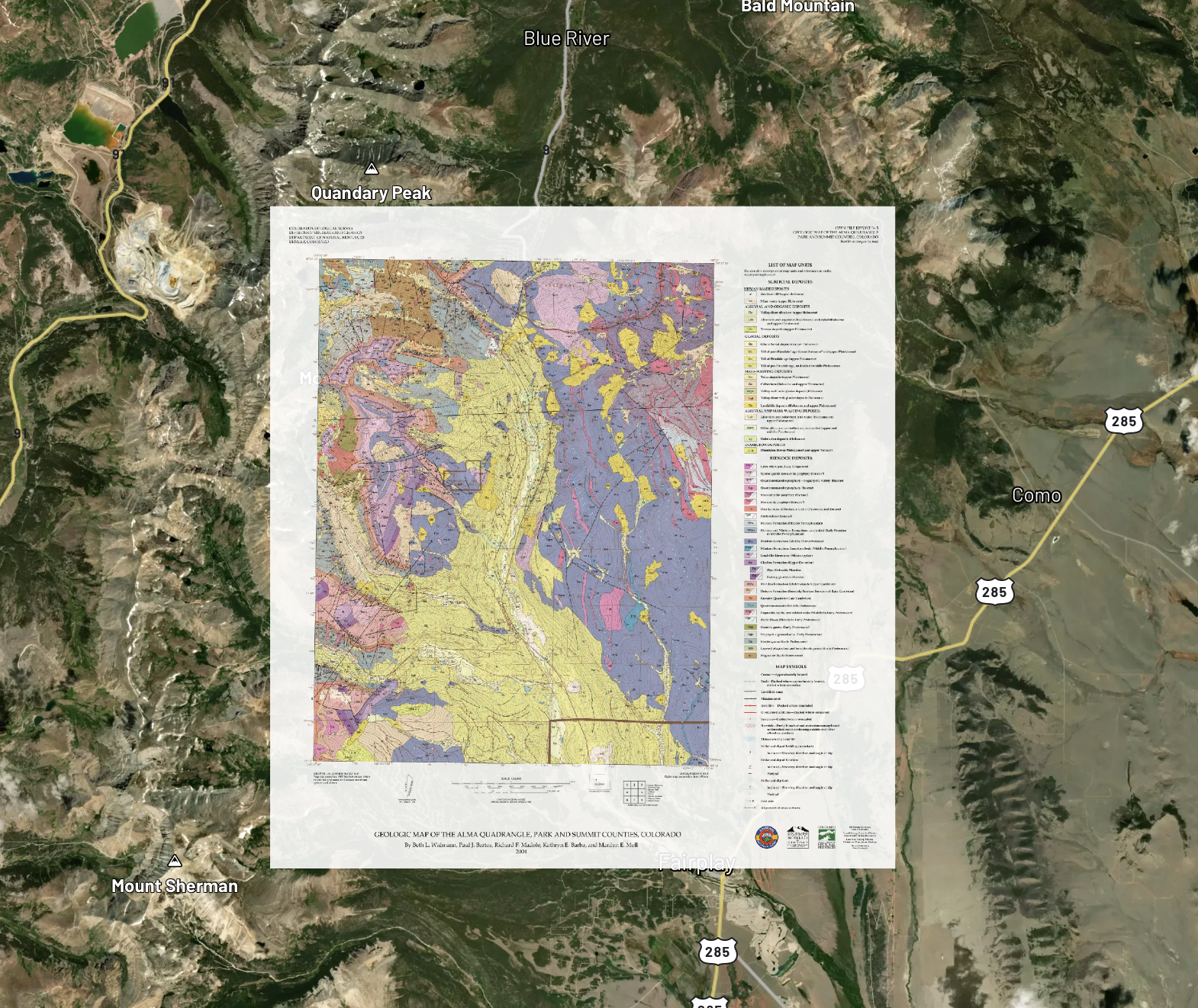
USGS map
Layers
Drill logs, assays, and geochem. Structured in seconds.
Monarcha reads drill hole logs, assay certificates, lithology records, and geochemistry results. Collars get coordinates, intervals get grades, every field gets a confidence score. Output as structured JSON ready for your modeling tools.
Learn about extractionExtracted Data
7 fields
DDH-2024-0147
512,847.3 m
7,234,102.8 m
225°
84.5 – 91.2 m
1.43%
Polygons, lines, and points. Extracted from any map.
Beyond georeferencing, Monarcha digitizes geological units, fault lines, drill hole markers, and any other features on your maps into vector layers. Edit, refine, and export as shapefiles. State-of-the-art accuracy that continues to improve.
Learn about digitization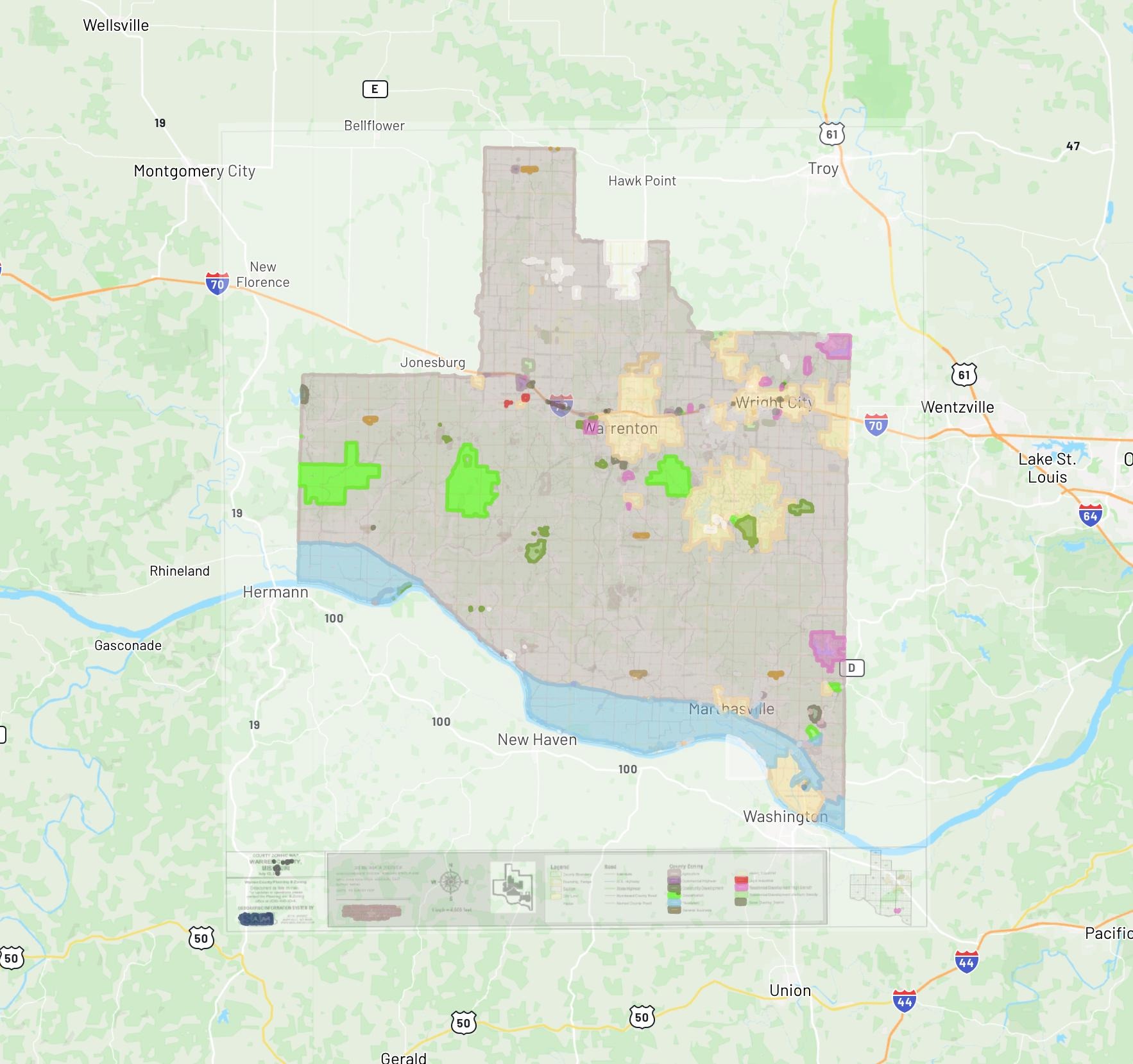
Digitize Layers
meriwether_zoning_map.png
Zoning Districts
Parcel Boundaries
Road Centerlines
Municipal Limits
Ask questions across your entire document archive.
Natural language queries across every document you've processed. "Show all drill holes with Cu grade above 1% from 2019 drilling at Site X." Unifies maps, drill data, reports, and geochem into one searchable system.
Learn about searchCu 1.43% @ 84.5–91.2m
Cu 2.11% @ 112.0–118.6m
Cu porphyry zone identified
Cu 1.07% @ 67.3–74.1m
Output goes straight into the systems you already use.
GeoTIFF, Shapefile, GeoJSON, structured JSON, CSV. Direct integration with ArcGIS, Leapfrog, and any GIS or data management platform. Full audit trail from source scan to database record. Nothing changes in your workflow.
Request a demoExport & Integrate
3 outputs ready
Select format
Send to
Built for accuracy at scale
AI-powered georeferencing
Industry-leading vision AI identifies coordinate systems, matches control points, and georeferences maps automatically, including local grids and UTM.
Learn about georeferencingDetected: NAD83 State Plane Georgia West (EPSG:2240)
Structured spatial output
Each document becomes a dataset. Monarcha extracts land descriptions, coordinates, and plotted geometries, transforming text and imagery into queryable GIS layers.
Learn about extractionBuilt for enterprise teams
Trusted by mining companies, government agencies, and engineering firms to process sensitive geospatial data securely and at scale.
Request a demoRecent highlights
Introducing the Survey Map Georeferencer
Our new AI georeferencing engine, trained on 100,000 annotated map pairs, aligns historic plats and surveys to modern coordinates in seconds.
Soviet Military Maps of China, Georeferenced and Open
Hundreds of classified Soviet 1:200k topographic maps of China, georeferenced and made browsable in a free, open atlas.
Raster to Vector: Converting Zoning and Land Use Maps to GIS Data
A practical guide to converting scanned zoning maps into attributed vector GIS data using AI.